Spatio-temporal data mining: application to the understanding and monitoring of soil erosion (FO.S.T.ER.)
- Period: 2011-2014
- Funded by: French National Research Agency ANR.
- Partners: University of New Caledonia (coordinator), LIRIS, LSIIT, LISTIC, BLUECHAM.
- My role : Task coordinator (Data preparation and Expert validation)
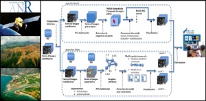
The FOSTER project aims at providing to geologists a semi-automatic and complete process for monitoring soil erosion. This process will be based on multi-temporal very high resolution satellite images coupled with digital elevation model (DEM), sensor data and/or expert knowledge. The project will focus more precisely on two important aspects of this process: segmentation of satellite images based on collaborative methods, and construction of descriptive (patterns, clustering,...) and predictive (decision trees,...) spatio-temporal models. This project focuses his study on New Caledonia, a biodiversity hotspot and a first rank environmental observatory. Protecting and managing such a fragile environment due to major mining projects and an increasing population, are major challenges. To valid the genericity of the proposed process, the project will also study another geographical area in the southern part of French Alps.